
When the Sanitary Commission replaced General George Don’s Paving and Scavenging Commission in 1865 one of its principle remits was to try and do something – anything – to alleviate Gibraltar’s perennial problem of overcrowding and the poor quality of its accommodation to its less well off residents. They were remarkably unsuccessful and by the time of the next census in 1871 the civilian population had increased to nearly 19 000 with little or no concomitant improvement in housing.
Let me give you a few numbers. The population of Gibraltar in 1860 was close to 18 000. Given that the area of the town proper was .25 of a square mile, that gives a population density of some 72 000 people per square mile. To put these figures in perspective, in 2015 - and according to the United Nations - Monaco was the country with the highest population density in the world – nearly 26 000 souls per square kilometre. Gibraltar was still up there with the best of them with the second highest for a European country albeit with a much reduced figure of about 5000.

Engraving of the Rock showing the rather small area occupied by the town at that time ( 1860s – A. C. Andros )
Even after two world wars and the slow march towards local self-government, Gibraltar continued to be regarded by the British authorities as primarily a military fortress and as an important base for the Royal Navy. Given the acute shortage of housing the preservation of historically important buildings and other structures were given a very low priority by both the colonial and the local authorities.
By the beginning of the 1980s the population had risen to about 27 000, housing was still at a premium and all thoughts concerning the preservation of what many considered to be Gibraltar’s Heritage sites and buildings were as yet anything but foremost in the minds of local government officials.
It was in this environment that somebody in 1982 – I am not sure who – brought out a publication with the title Save Gibraltar’s Heritage. It was essentially a critique about what had gone wrong, what had not been done that should have been done, and what ought to be tackled in the future. Copiously illustrated it still gives the reader a flavour of what were considered at the time to be important heritage sites worthy of preservation.
Below are copies of the photographs that appear in the book together with comments. The whole was prefaced by an introduction written by George Allan which I have also included. I would also like to acknowledge that everything that follows has been kindly made available to me by the local amateur historian Nelson Mario Yome – Thank you Nelson.

The Introduction - Safeguard’s for Gibraltar’s Heritage – by George Allan
As a self governing colony, Gibraltar has complete control over its own environment. Its civilian government led by a Chief Minister appointed by the Governor from the majority party in an elected House of Assembly, is in overall charge of all domestic matters except foreign policy and defence under a Constitution made by the United Kingdom Government in 1968.
Its planning system is a simple one. A Development and Planning Commission, chaired by the Economic Development Minister and composed of two Government appointees and the permanent and development officials, considers all applications for the permits which are, under the Town Planning Ordinance of 1973 necessary for the construction, alteration or demolition of any building.
Every five years the Ordinance requires a “Planning Scheme” to be produced. This document, the Gibraltar Plan is the equivalent of a district plan. The current plan produced in 1976 was accompanied by an impressive analysis of the problems faced by the Rock, although its somewhat rigid land-use zoning has now been superseded elsewhere by a more flexible framework of policies.
A separate Museum and Antiquities Ordinance 1970 establishes a Museum Committee appointed by the Governor, to which is entrusted not only the town’s attractive museum but also the supervision of the Rock’s scheduled ancient monuments.
Given the enormous uncertainties that have surrounded the future of the Colony in recent years, the system has worked tolerably well. The mistakes made – the new hotels and apartment blocks in particular – are no worse than those seen in Britain and are with few exceptions, regretted. In some respects – noticeably demolition control and powers to enhance the external appearance of buildings Gibraltar is arguably in advance of the United Kingdom even if these powers are rarely used.

The Franco regime closed the Spanish frontier with Gibraltar in 1967 - It partially reopen in 1982 - The “enormous uncertainties” mentioned by Allan refer to this era in Gibraltar’s more recent history
Yet it is now clear that Gibraltar has outgrown its planning procedures. Not only does the present system have some surprising gaps but it must be doubtful whether it would be able to cope adequately with any development boom which might result from the opening of the frontier. If Gibraltar is to develop in harmony with its heritage and it superb natural setting its planning law must be an early candidate for radical overhaul.
The most remarkable facet of the system is the almost complete absence of any form of public participation. The only statutory provision for public consultation concerns the planning scheme itself. For two months in every five years the new Scheme has to be exhibited, an objector can appeal to the Governor if his objection is not met by a modification proposed by the Development and Planning Commission.
Applications for planning permission are neither advertised nor open to public inspection. No-one has the opportunity to comment on them and the Commission considers them in private. The Commission itself is drawn from such a small Government dominated circle that there is little opportunity for outsider views to be heard. Informal consultation by the Commission with the Museum Committee is no substitute for more broadly based decision making body.
The Photographs

Prince Edwards Road and the facade of the former Gavino’s orphanage, now Government housing

Gibraltar Heights in Main Street with the Roman Catholic Cathedral on the left
The new building is in both scale and design at odds with the character of the old town.

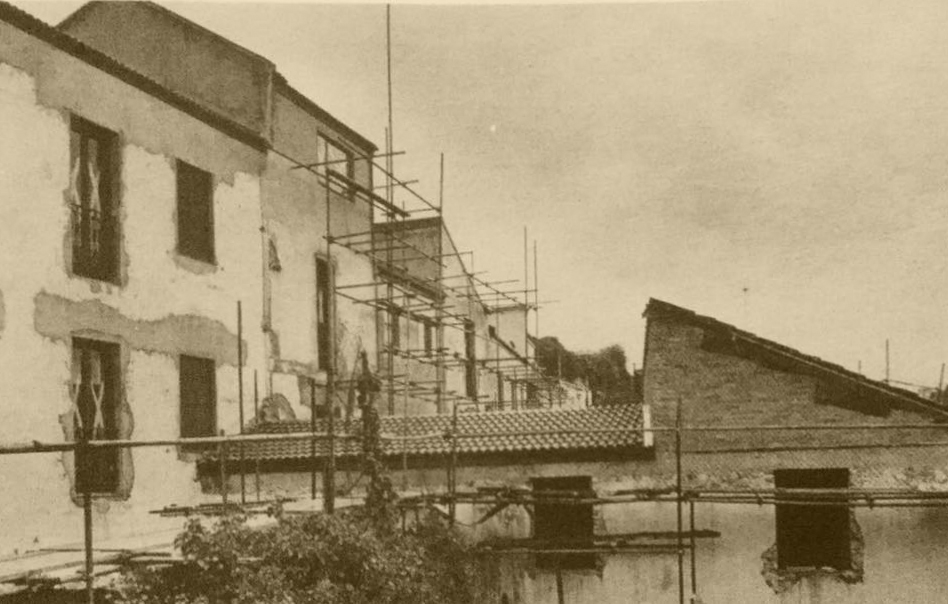
The Spanish Pavilion being demolished in the 1960s
The original 18th century Spanish Pavilion block was built on the site of an older pre-1704 Spanish barracks. It was demolished to make way for Gibraltar Heights

The Royal Naval Hospital

The Royal Naval Hospital ( 20th century photograph )
Originally known as the British Military Hospital, it was finished around 1904. It was transferred to the Royal Navy in 1963 and renamed the Royal Naval Hospital. During the first decades of the century it was known as Wedgwood Castle. Some have suggested that this was because it had originally been painted light blue - others that it was built from local stone some of which can be grey blue in colour.

Castle Road
Police Officers Married Quarters to the right – The Church of the Sacred Heart can be seen bottom left.

Castle Steps leading up to Castle Gulley
A remarkable labyrinth of steps and huddling alleys – the old Lourdes School to the right - to the left the “Caño Real” a well known children’s slide. On the left at the top of the steps is the Artillery Arms Bar.

Castle Steps ( 21st century view - with thanks to Andrew Smith )

House in Bomb House Lane
Typical Gibraltar balconies in the old town.

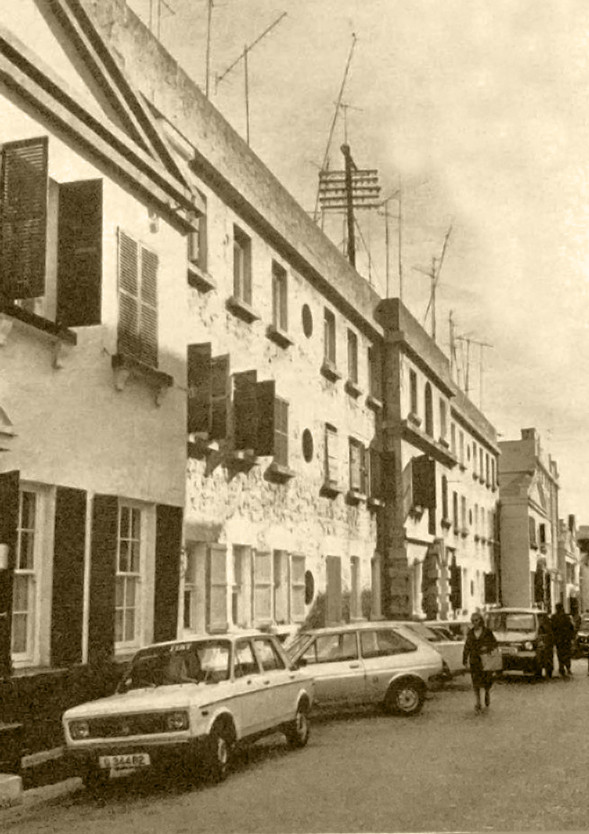
Irish Town
This was the old commercial street of Gibraltar. A number of the houses survive.

Looking down on Parson’s Lodge Battery
Napier Battery with Fortress Headquarters is immediately to the right. Neither battery is protected by Ancient Monuments legislation and both sites are earmarked for hotel development. Note that the early 19th century Victualling yard is left unmentioned.

Victualling Yard

King’s Lines
An illicit “chicken run” is under construction on the scheduled Ancient Monument.

Entrance to the King’s Lines
Several feet of debris is blocking the entrance to one of Gibraltar’s major historical sites.

Engineer House
A fine early house in a large garden in the old town left to decay after transfer to the Gibraltar Government. Three quarters of the house was made of wood and long before it was taken over from the military authorities it was already falling to bits.

Officers Quarters in Cannon Lane
Sixty such quarters, well maintained by the Property Services Agency are likely to be relinquished in the near future offering a major opportunity for imaginative alternative use.

Proposed covered markets in front of the Gibraltar Assembly published in the Study Group Report of 1965.

The “Piazza”

View from Parson’s Lodge Battery
In the foreground are the roofs of the victualling yard – The new housing immediately behind is to be continued round the bay along the empty site tp the left, transforming the character of one of the most picturesque parts of Gibraltar.

Rosia Steps behind Rosia Bay
The new housing on the right might be anywhere in England, the stuccoed buildings on the left, though modest are of the type that give character and charm to so many Mediterranean fishing ports – They are to be demolished as the housing scheme on the right is extended.

Entrance to new shopping arcade
Concrete canopies have been applied with no regard to the character of the existing buildings, continuing across two houses while the cornice of the building on the right has been removed - Sash windows have been replaced by casemates.

Main Street

North end of Main Street
The two story building, matching its neighbours in Cooperage Lane provides a picturesque incident at the entrance to the old town. There are already pressures however to add an extra storey.
The photo was actually taken looking north from near the Cathedral of St Mary the Crowned or more or less from the middle rather than the north end of Main Street.

Casemates

Castle Street
Castle Street
Both the Casemates and Castle Street were Conservation Action Areas – The Independent Report suggested that the buildings in these areas should be improved internally and exteriors repaired and painted but not physically altered.

View over the waterfront
The quay on the left is part of the Naval Dockyard. On the right, linked to the shore by a causeway is Coaling Island, still required by the Navy for operational purposes. In between is the town’s small marina, and it is suggested that the sheds immediately behind could be cleared to open up part of the old town directly on to the waterfront.

View over the northwest end of the Rock
This also shows how the old town has been cut off by the sea. The success of the new marina to the left of the airstrip demonstrates how access to the waterfront is much in demand.

The Gardiner’s Road Development with Charles V Wall on the left

Naval Dockyard
The extensive series of repair shops may be closed though there are hopes of finding a commercial user. Note the two octagonal stone chimneys.

View from Parson’s Lodge over the south end of Rosia Bay
The old Naval Hospital is on top of the cliff in the foreground on the left. It is currently used as Married Quarters and is a candidate for conversion as a hotel. Behind, new villas are creeping up the hillside.

Town Range
This major range of Georgian Ordinance buildings consists of three blocks linked by four lower pedimented pavilions – Most of the buildings are empty or likely to be evacuated in the near future – until now it has been envisaged that the entire group would be demolished – Here it is suggested it could be converted as a new hotel – Guest rooms would open on to the Galleries behind - Note . . .the pedimented pavilions built as officers’ houses - The heavy “rustification” recalls the work of Vanbrugh for the Ordinance in England

The original barracks was designed and built in the mid 18th century by Jas Gabriel Montressor – chief engineer of Gibraltar at the time (See LINK)

The Rock seen from Europa Flats
The southern tip of the island has been largely paved over as playing fields, but landscaping could make this important tourist site much more attractive.

Main Street
This is a graphic example of the disfiguring of traditional buildings by the addition of extra storeys.

Flight of steps leading to the Lines from Casemates Square
The locked gates prevents people from using the steps.

Bomb proof Barracks on Princes Lines
The extensive lines at the north end of the Rock, built as a protection against Spanish attack are potentially one of Gibraltar’s principle tourist attractions.
Thank you again Nelson for your help.