
People who like looking at old photographs of their home town - and I certainly do - will eventually have to confront a very simple question - who took the oldest extant pictures and where can I find a digital copy?
The truth is I am not all that interested in the general history of photography – or even trying to recognise the differences between the many photographic techniques that surfaced during the mid 19th century - Henry Fox Talbot’s calotypes from 1835 and Louis Daguerre and his daguerrotypes from 1839 come to mind. In any case neither of them as far as I know ever photographed Gibraltar.
However, Charles Clifford (see LINK) and Francis Frith (see LINK) both did and produced some impressive old photos using the collodion process. Clifford’s work can possibly be dated from as early as 1861 – Frith’s perhaps not very much later than that.


Windmill Hill and Barracks ( 1860s - Francis Frith )
From then on people like Jean Laurent (see LINK) and James Hollingworth Mann (see LINK) working from the late 1860s to the early 1890s produced what I consider to be some of the finest photos of the Rock ever – regardless of when they were taken.


Gibraltar from the Rio de la Miel in Algeciras ( 1880s – Jean Laurent )
However. . . and this is a brand new “however” . . . . it is only very recently that I have become aware that predating all of these Rock-taking photographers is somebody called Alfred Capel Cure. Two albums of photos taken by him are held by the University of California in Los Angeles gathering their usual decades of dust and seen by only the very, very few indeed. They contain about 300 salt prints of which 24 in the second album were taken in Gibraltar.
What little I know of Capel Cure can be summarised rather quickly. He was an officer in the British Army, originally commissioned into the 55th Regiment of Foot. He later fought in the Crimean War where he was badly wounded. He was promoted to Lieutenant-Colonel in 1856 and then to Colonel five years later.

Brevet Lieutenant Colonel Cure in 1856 ( Probably a self-portrait )
He was stationed in Gibraltar as a member of the 55th from 1851 to 1854 being promoted to captain more or less half way through his time on the Rock. His Gibraltar photographs are dated 1851 and 1852 which will almost certainly make them among the earliest ever taken of the Rock.

Memorial to Alfred Capel Cure, on the wall of the chapel he had built in Badger’s parish church.
His uncle - the artist Robert Henry Cheney - taught him photography, and by 1850, Capel Cure was already dabbling in salt prints focussing mostly on architectural subjects.
The following are a selection of the UCLA held Gibraltar photographs. All of them have required a heavy dose of digital editing.
The following are a selection of the UCLA held Gibraltar photographs. All of them have required a heavy dose of digital editing.
Alfred Capel Cure’s photos of Gibraltar

1. View of Gibraltar – West side from Old Mole Head
The lenses available to Capel Cure – and many others who followed him - were incapable of taking in the entire Rock from this particular perspective. The photographer therefore resorted to what was at the time a rather original option - He took three distinct photographs and stitched them together accordingly – thus anticipating a commonplace digital technique by a century and a half.
The result is a classical view which had already been painted by several early 19th century artists - and photographed by many other photographers after him in the late 19th and early 20th century. The Old Mole with its long array of guns pointing towards the northern area of the isthmus was appropriately known by both the British and the Spaniards as the Devil’s Tongue.
In later 19th century photos, a similar set of cannons appear on the opposite side of the Mole defending the Bay to the south. Whether this was the case in the early 1850s is impossible to tell from the Cure's photograph
In later 19th century photos, a similar set of cannons appear on the opposite side of the Mole defending the Bay to the south. Whether this was the case in the early 1850s is impossible to tell from the Cure's photograph
The northern section of the Line Wall is visible as a broad white object running at right angle to the Mole at the end of which is a neat dark rectangle which could be either an editing artefact or Chatham’s Wicket (see LINK) which together with its drawbridge was the entrance and exit into and out of the Mole.
A picture by Thomas Whitcombe dated 1816 (see LINK) - which was almost certainly based on another dated 1804 by Lieutenant Henry Aston Barker (see LINK) shows some of the features mentioned above and confirms that at least up to the date when the pictures were painted there were no cannons on the Devil’s Tongue that faced south. By 1893 a new but similar view (see LINK) that appears as an illustration in Henry M. Field’s travelogue - Gibraltar - (see LINK) shows the Mole with cannons on both sides.

2. View of Gibraltar North Front from Neutral Ground
This one was also created by joining up two photographs. Again a much photographed view this time of the Rock at its most imposing - a demoralising sight to any army intending to take the Rock by storm across the isthmus. Whatever man-made structures may have been present beneath the North Face are overwhelmed by the sheer mass of the rock itself.
Although generally lacking in detail, the Great Sand Dunes – the water catchments as yet not even a figment of anybody’s imagination – are clearly visible on the left and eastern side of the Rock. There is also the suspicion of a column of rock to the left of the lighter area in the middle, a distinctive feature of the cliff face known in the past as la Virgen because of its perceived resemblance to the Virgin Mary. This photograph can be usefully compared with one by Francis Frith which was probably taken about ten years later. (See LINK)

3. Moorish Castle and Walls from Montagne Cavalier.
By “Montagne” Capel Cure probably meant Montagu. The use of the word “Cavalier” is also unusual. Montagu Bastion – named after the first Duke of Montagu – was constructed one year after Anglo-Dutch forces took over the Rock in the name of the Archduke Charles of Austria. (See LINK) According to John Drinkwater (see LINK) who wrote the definitive history of the Great Siege, (see LINK) Montagu “Cavalier” was essentially a raised mound which was built in 1782 following the pentagonal shape of Montagu Bastion below it. I think that this is the fortification that Cure is referring to. (See LINK)
The view looks east towards the Moorish Castle, the old town with the Casemates and Barracks occupying the lower section of the photograph. Again a much photographed view as can be appreciated from the following link to one dated 1875 and attributed to Francis Frith. (See LINK)

4. Gibraltar, Signal Station from Montagne (sic) Cavalier
This particular photo is dated March 1851. The quality of this reproduction is not good enough to show Signal Station which would have appeared on the top left hand side of the Rock. The blurred objects on the bottom right are probably cannonball pyramidal stacks – a common feature in the fortress at the time.
Haser and Menet’s 1891 photo of the Rock taken from Spain shows a similar angle although it was taken a considerable distance from that used by Cure. On it, however, one can appreciate the Signal Station and – a subsequent construction – the aerial railway pylons leading up to it. (See LINK)

5. Our Garden - Casemate Barracks from Montagne Cavalier
A very similar perspective to the previous photo but with a view slight more towards the north - Casemates Square and the Barracks are clearly visible. The “garden” on the right may possibly have been a precursor of what would later become Montagu Gardens. (See LINK)

6. View of Gibraltar from Road to Flat Bastion looking north
This is the right-hand section of a two frame photograph of the town. I have omitted the impossible to interpret left-hand section. The poor quality of both does not allow for any real discussion about it. However, I would imagine that the Moorish Castle would form part of the top right hand corner of the shot much as it appears in what might be a similar photograph by Jean Laurent taken in the 1880s. (See LINK)

7. View from Artillery summer house towards Africa (Apes Hill)
Again the quality is too poor to make out anything of interest. Apes Hill (see LINK) on the other side of the Straits is visible as a small hump on the horizon in the middle section of the photograph. The Artillery summer house itself is an unknown quantity.

8. Jumper’s Bastion when Gibraltar was entirely British – Looking South
Despite the blur I can make out the Alameda Gardens (see LINK) with its many small pathways on the left and the flat area of Grand Parade just below it bottom right. Jumper’s Bastion (see LINK) appears as a straight line facing the sea, ending in what might be the rather faint outline of the New Mole further south with several ships at anchor.


9. Panoramic View from Road to Flat Bastion - Sweep from South to North starting with the photo on the left
It is possible to make out Sierra Carbonera to the right on the Spanish side of the Lines. (See LINK) The rest is simply a blur. A clearer picture would have shown the Moorish Castle on the top right hand corner as it does in this similar photograph probably taken by Robert Peters Napper in the 1870s. (See LINK)

10. View of “The South” From Queen Charlotte’s Battery Road
It’s hard to make out anything at all from the left hand shot and not too much more from the one on the right either. However in its original state this must have been quite an all-encompassing view towards the south as Queen Charlotte’s Battery was just above the Moorish Castle Precinct.
The original version identifies various sites such as the Convict Establishment (see LINK), the Officer’s burial ground, the memorial to Wellington in the Alameda Gardens, South Barracks (see LINK), Whimpers House, Rosia Bay (see LINK), and . . . Queen Charlotte’s Battery itself. I cannot find a similar shot to this one elsewhere but one taken by Hollingworth Mann taken from a lower perspective points generally in the right direction. (See LINK)

11a. Bird’s eye view of Curtain of lairs of Casemates . . . . .
An identifiable shot of the Casemates with the Waterport (see LINK) leading on to the Commercial Wharf and the Old Mole. In the middle of the photograph and to the right of the Casemates is the Grand Battery with its many canons pointing towards the Neutral Ground and Spain. The photo was probably taken from the Moorish Castle area as was this comparable one by Hollingworth Mann. (See LINK)

11b. . . . . & of Neutral Ground with approach by Landport
This one shows the road to Spain with the Bayside Barrier at the junction of the road leading towards the east. The bay lies to the west of the bottom section of the road and the Inundation to its right – In the far distance the town of La Línea.
The continuation of the bottom section has been drawn in by hand by Capel Cure and shows part of the northernmost section of the Bay. Despite the title, Landport (see LINK) lies out of sight beyond the extreme bottom left hand corner. A very similar view was taken from Hanover Battery by James Hollingworth Mann in the 1870s. (See LINK)

12. Part of Bay of Gibraltar, looking S.W. from flagstaff, Montagne (sic) Bastion
The flag was close to the shoreline and not far from the Waterport Gates. The photograph must have been taken from the south west edge of the pentagonal of the Montagu Bastion. The view looks across the Bay towards Spain in the general direction of Algeciras or even further south. The ships – almost all of them appear to be sailing boats - are anchored well away from Line Wall avoiding dangerous rocks and shallow waters. Hollingworth Mann’s photograph identifies the flagstaff as well as Montagu Bastion and Cavalier. (See LINK) The view towards Spain and the Bay is slightly more to the north than Capel Cure’s.

13. View of Queen of Spain’s Chair & the Lines. Looking North
The Spanish Lines lie to the right with the town of La Línea behind them. The cone of Sierra Carbonera to the left and on the opposite Spanish coast is clearly visible. The tower on the top of the hill known to the British as the Queen of Spain’s Chair is not. The boats - anchored in the relatively sheltered waters of the northern part of the Bay - are mainly feluccas typical of both Gibraltar and the Mediterranean at large.

14. View of the Rock from our Garden (1852 )
(Original print with the University of California in Los Angeles - with thanks)
Capel Cure pointed his camera northeast taking in the walls that surround the Moorish Castle. On the extreme top left and only partially in the picture is the Tower of Homage or Moorish Castle itself. It is shameful to admit that I am still unsure as to who exactly was responsible for the building of what is in effect the most important heritage site on the Rock. I am not even sure when it was built. And I am not alone in my amateur ignorance – the professionals don’t know either. (See LINK)
The massive more or less northwest facing defensive walls continue from left to right and are the main focal point of the photograph. Over the years there have been countless photographs of Gibraltar’s Castle taken from many different angles but this is the only one I have come across that shows this particular wall in all its complete and magnificent glory. It would have been built by the Moors but will have had additions and improvements made to it by subsequent Spanish and British engineers. (See LINK) The five or perhaps six gun battery will almost certainly have been a British addition.
On the right hand side the wall ends with the Stanley Tower which was named after Lord Stanley - Secretary of State for the Colonies. He is reputed to have been responsible for the purchase of its clock which is clearly visible in the photo. It was only about seven years old at the time as it was installed in 1845.
The tower itself actually dates from the 12th century. It was built under the direction of the Moorish architect al-Hajj Ya'ish of Malaga by order of Abd-al Mu’min, the first Caliph of the Almohades and founder of the original town of Gibraltar which he named Medinat-al-Fath. (See LINK)
In the middle of the photograph, to the left of the Stanley Tower, is the pyramidal roof of the so-called Gatehouse. It lies behind the main wall shown on the photograph and was part of a similar and parallel southwest wall. It too was part of 12th century Medinat-al-Fath and was known at the time as Bab-al-Fath – the Gate of Victory. The pyramid shaped roof was probably a 17th century Spanish addition. The entrance was blocked up and the area inside it used as a powder magazine. The British continued to use it for the same purpose.
The bottom bit contains a rather sparse collection of buildings which will have formed part of Villa Vieja or the Old Town. Most of the more attractive houses in this area would have been on the left and do not appear on the photograph.
Privately owned herds of goats that were once allowed to roam the Rock above the Castle and elsewhere seem to have eaten every available plant leaving it with a rather sterile appearance.
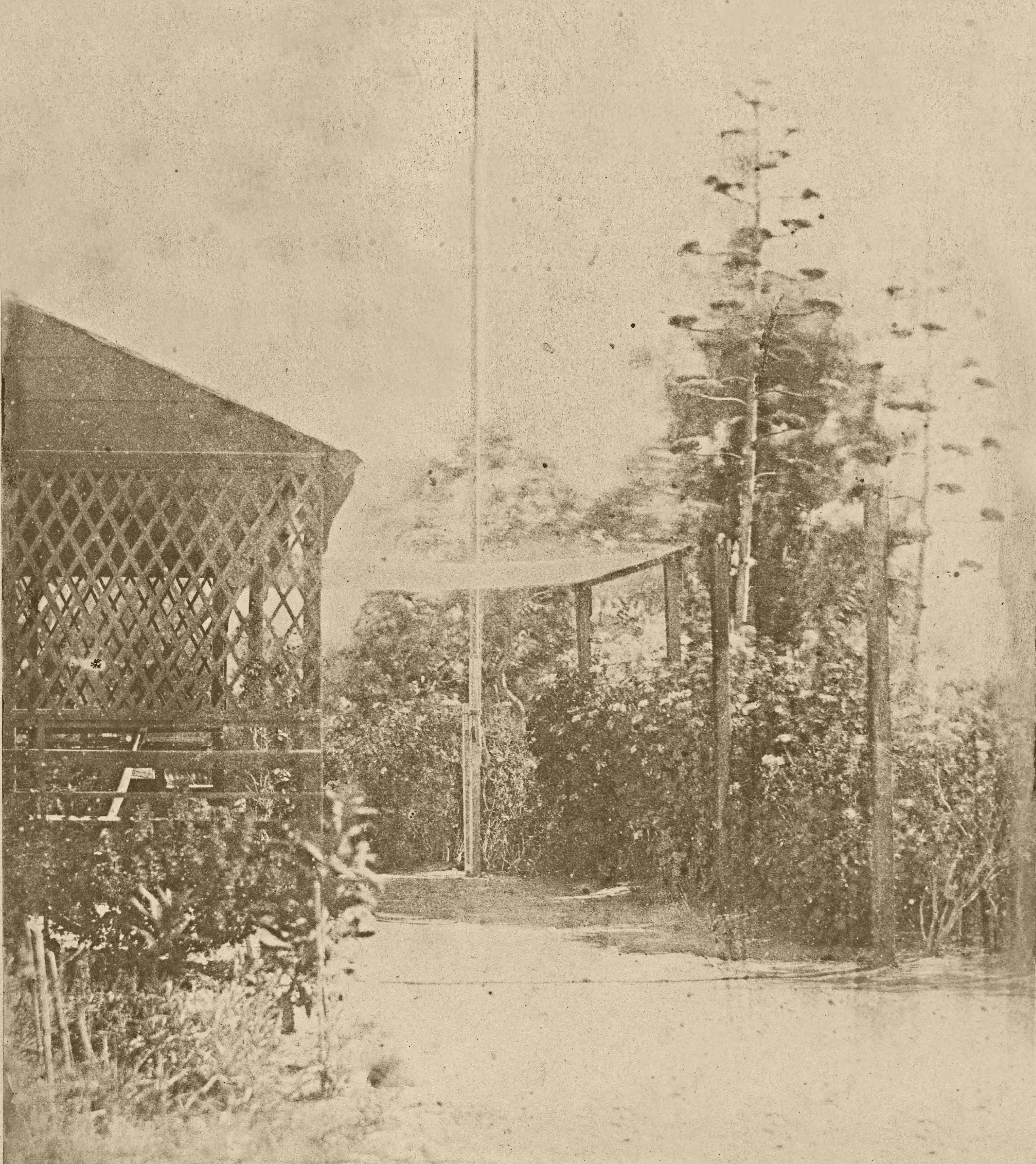
15. Our Summer House
Impossible to pin-point where exactly this summer-house might have been. The presence of a mast – barely visible in the middle of the photo - suggests that it might refer to a military rather than to a civilian location. At least two of the plants can be identified as flowering century plants - Agave americana. As an introduced species it was - and probably still is- quite common on the Rock. It has often been used for dramatic effect by later photographers of the Rock – as shown in this photo of Gardiner’s Battery by Mann. (See LINK)

16. The Garden
The garden in question presumably belongs to the house that appears on the right. The rest is undecipherable although most of the plants lining the bottom area are probably Agaves.

17. Part of Bay - From the Garden
Presumably taken roughly from the same place as his other garden photo (no 14) but facing north-west. If so then the bastion is Montagu’s. One half of Sierra Carbonera is visible in the far distance. The boats would be anchored to the north of the Old Mole.

18. Towards Algeciras from Grange Counterdguard (sic) from the Garden
Grange Counterdguard is Orange Counterguard named in honour of King William of Orange. It was later renamed Chatham Counterguard a change of honour to the Earl of Chatham (see LINK) who was Governor of Gibraltar from 1821 to about 1835 although he spent most of that time as an absentee landlord rather than the real thing. The counterguard lies just slightly to the North of Montagu Bastion and the view is towards the town of Algeciras with la Sierra de la Luna behind it.
Plenty of visible details on this one including the well cut ashlars used to build the counterguard. Cannons face towards the Bay and a largish sailing ship in full sail seems to be moving towards them. The gateways are probably entrances into the Counterguard.

19. Slope of the Rock as seen from Whimper’s Garden
Quite a few tantalising details in this one – a dome shaped building or arbour, a cleared space in the middle of the composition - none of which can I identify. Whimper of course, continues to be an unknown.

20. My Beasts. 1 Feb 1852 Gibraltar. (Collection of Butterflys, insects, etc.)
Self explanatory and I will leave it to the experts to identify the different species of his collection which – presumably – are made up of local fauna. It is a wonderfully eclectic mixture of scorpion, sea horse, moths, crickets, locusts and so forth - not to leave out what appears to have been his piece de resistance – huge bat-like moth.

21. (Mirror images of) Candlesticks etc. Casemates (1852)
A surprisingly good photograph considering that it was taken indoors but probably made possible by the “still life” subject matter which allowed him to use a longer exposure. Flowers in a jar, a tall lamp, two candleholders with candles and what appears to be yet another collection of “beasties” are all clearly discernible.

22. Elton, Hume, Hannay. Summer House
The three named people are unidentifiable, but the trellis behind them is similar to the one that appears in the Summer House photograph. The house on the right could also possibly be the same as the one on the Garden photo.

23. Marsh – (Gib 1852)
Almost certainly a portrait of one of his friends.

24. A.C.C. – (Gib 1852)
A.C.C. must be Alfred Capel Cure.

A comparison of the two previous photographs shows that both were taken with the similarly posed subjects sitting on the same sofa. Could A.C.C.’s photograph have actually been “taken” by Marsh? It is also apparent that the study on the left is less well focused than that on the right. My guess is that Capel Cure was much more aware of the need to keep absolutely still – particularly when attempting indoor shots requiring long exposure times.
All the photos shown above have been digitally copied from a very poor quality pdf set taken from El Gibraltar de 1851-1852 en los Calopitos de Alfred Capel Cure – an article written by Juan Carlos Pardo González. To make matters worse his were taken from copies obtained from the Instituto de Estudios Campogibraltareños of Algeciras. According to Juan Carlos these are not particularly good copies either.
The result of all this is that I have been forced to abandon all historical principles by digitally manipulating the photos – even to the extent of changing their colour to sepia rather than leave them in black and white. My only excuse is that I wanted to produce semi-recognisable photographs – rather than a series of undecipherable image. My hope is that they will wet somebody’s interest to such an extent that they will buy proper copies from the University of California in Los Angeles – something which I personally cannot afford.
Finally my sincere thanks go to Juan Carlos Pardo González who brought these photographs to my attention – my abject apologies to you for having plagiarised so much of your wonderfully researched paper.
Grácias Juan Carlos.
Postscript
I wrote this article almost exactly 6 years ago. Since then UCLA has very recently digitised Capel Cure's photographs. They seem to be available for download by anybody.
Rather than rewrite - something I would rather not face, I have simply replaced the photos I posted originally with these newer and better copies.
As such please forgive me if you find that the comments in the text below at least some of the photos, are not as relevant as I might have wished.
Rather than rewrite - something I would rather not face, I have simply replaced the photos I posted originally with these newer and better copies.
As such please forgive me if you find that the comments in the text below at least some of the photos, are not as relevant as I might have wished.
Tuesday 3rd May 2022.