
I am not exactly sure when or for how long, but by the early 17th century Gibraltar had three north facing land gates.
1. Puerta del Castillo – Accessed from the Castle precinct – I know very little about this one. I can’t find it in the literature but it appears on some maps and plans. The very early 17th century Spanish engineer Capitán Cristóbal de Rojas identified it as a false gate – whatever that might mean.

The Northern Defences with three north facing land gates (1627 – Luis Bravo de Acuña)

The Northern Defences (Cristóbal Rojas 1607)
2. Puerta de Tierra. Possibly the most important one as this was the easiest to use for access to and from Spain – hence its other name – Puerta de España. It appears on just about every map of Gibraltar from Wyngaerde’s 1567 plans onwards and is labelled on Bravo’s 17th century maps as la Puerta de España. Post 1704 British maps show it as Landport Gate.
3. Puerta de Granada – This one was accessed from Villa Vieja. It appears on Anton Wyngaerde’s and Bravo’s work. Bravo calls it la Puerta de Villa Vieja. I suspect that this was the name commonly used to describe the older southern gate of Villa Vieja which allowed people to communicate with those of la Turba and vice versa. La Puerta de Villa Vieja is mentioned several times by Alonso Hernández del Portillo in his Historia de . . . Gibraltar. He infers that this was the name given to the southern gate rather than an alternative name for La Puerta de Granada.

(1627 - Crop from a plan by Luis Braco de Acuña)
The Problem with la Puerta de Granada
La Puerta de Granada, una gran entrada monumental medieval situada más arriba, en la ladera de la montaña, fue perdiendo importancia hasta desaparecer en época inglesa.
I couldn’t agree more with Ángel Sáez Rodríguez’ comment in his article Gibraltar en 1704 – although I must say that I still cannot find a single instance in the literature in which la Puerta de Granada was ever considered of any importance.
In 2006 the Spanish archaeologist Francisco José Giles Guzmán and others published their article La Puerta de Granada de Gibraltar, Nuevas aportaciones. An informative piece of work with a promising title, it offered the reader:
. . . las interpretaciones y resultados obtenidos tras las excavaciones arqueológicas realizadas en el solar donde estuvo ubicada en época islámica la Puerta de Granada.And the article does indeed cover just about everything you ever wanted to know about the gate but were afraid to ask . . . except for one thing – it does not explain the reason why it was felt necessary to build this gate as an exit from Villa Vieja.
In other words, this gate is something of an enigma to me as I find it hard to understand why on earth it was decided to build such an imposing structure – at least by Gibraltar standards - in such an awkward and limiting location. A quick look at Wyngaerde’s mid 16th century plan reveals a rather nasty slope that would need to be negotiated by anybody who wished to use it to enter or leave Gibraltar.

The top gate on the right is la Puerta de Granada – the one below it further to the right, shown practically at sea level, is la Puerta de Tierra (1567 – Anton Van den Wyngaerde)
Wyngaerde’s plan shows what may have been a pathway behind a defensive wall known in the 17th century as la Muralla de San Juan. More to the point it also shows what appears to be some sort of access sloping downwards near the “casa de cal” or lime kiln which would deposit a traveller close to sea level. But it is by no means clear that such an ill-defined path was used for this purpose. In any case it would have been much easier for a traveller to enter the town via la Puerta de Tierra and get to Villa Vieja after a short comfortable stroll.
It could be that the gate was built to provide a direct entrance to Gibraltar’s more northern fortifications such as, for example, el Pastel – also known by the more prosaic la Torre Redonda or the Round Tower. It is an idea that is given some backing by Colonel D’Harcourt’s influential plan of the northern end of Gibraltar which he produced for Prince George of Hesse-Darmstadt just after the capture of the Rock.

E = “The Round Tower”, F = “The communication of the Round Tower”, Z = Gate near the Castle is now the communication to ye Round Tower” (1704/5 - Colonel D’Harcourt)
The “Gate near the Castle” is la Puerta de Granada and D’Harcourt is probably quite entitled to use the word “now” in his caption – El Pastel was constructed by the Spanish engineer Diego Luis in 1703 - only about a year before D’Harcourt produced his map. It was probably destroyed by the British not long afterwards.
Which of course does not negate the possibility that the gate was designed to give access to whatever defensive walls and fortifications may have been in place above the Puerta de Tierra. During the very early 17th century the Spanish engineer, Luis Bravo de Acuña had already come to the conclusion that the entire northern section including la Muralla de San Bernardo and its Puerta de Tierra – which eventually became the Grand Battery and Landport gate of the British era - was anything but up to scratch.
. . . en una de las puertas de esta ciudad que está en Villa Vieja de ella, que dicen La Puerta de Granada, obra morisca y muy de ver, que con ser antiquísima parece que se acabo hoy de hacer, y es de admirable arquitectura, es esculpida una llave por la cual se entiende y por la tradición que traemos de padre a hijos que los moros tenían a esta Ciudad en España, o de su Reino en Granada.And perhaps even more intriguingly:
Sin esta (Puerta de Tierra) hay otras cuatro puertas - la de la mar, (Waterport Gate) . . . Otra dicha de Mudarra . . . Puerto de los Baños . . . (y) Puerta Nueva (Southport Gate).
. . . Portillo not only signally failed to mention la Puerta de Granada but went out of his way to tell the reader that la Puerta de Tierra was the one and only land gate into and out of Gibraltar.
Queda en este muro (San Bernardo) la Puerta de Tierra con su Alcaide, y dice se así porque por ella, y no por otra, se sirve esta ciudad por la tierra.Well over a century after Portillo, this mid to late 18th century Spanish map mentions la Puerta de Tierra, Puerta de la Mar and Puerta Nueva - but not la Puerta de Granada.
Fast backward to 1540 when Gibraltar suffered the indignity of an event known as the “Turkish Raid” - a hit and run affair organised by a renegade Algerian commander. Unfortunately, a large number of locals had been working the vineyards the day before the raid and had spent the night out of town. When they eventually did return, they found themselves locked out and were unable to enter to give a hand.

From a 1781 manuscript of Alonso Hernández de Portillo’s Historia de . . . Gibraltar
The above reads as follows:
Ya por este tiempo se recogía mucha gente de las viñas que no se habían hallado aquella noche en la Ciudad y hallaron la puerta cerrada. El Alcaide había dormido aquella noche en el campo y la mujer con la turbación no hallaba las llaves, por esta causa u ocasión se abrió la puerta mas tarde de lo que se quisieraThe two key instances are the twice mentioned “la Puerta” in the singular - both of which refer to La Puerta de Tierra. In 1540 at any rate, La Puerta de Granada was obviously a waste of space. But to return to the general archaeological evidence offered by Giles Guzman which I think can be summarised as follows.
The possibility of la Puerta de Granada being built in the 12th century during the construction of Madinat-al-Fath by the Almohad caliph Abd al Mu’min must be discarded because of the lack of any real archaeological evidence.
In other words, Ibn Sahib al-Sala’s over the top narrative of the building of Madinat-al-Fath in the 12th century should be replaced the by equally glowing descriptions by Ibn Marzuq and Ibn Juzayy on the enormous construction projects both military and civilian carried out by the Marinid caliph Abu al-hasan and perhaps as well by his son Abu Inan Farris and later the Nasrids of Granada during the 14th century. In other words, the Gate was of either Marinid or Nasrid origin.
Taking as gospel truth a time-line included in a 2014 article by Kevin Lane et al - Myths, Moors, and Holy Wars – makes me realise that pin-pointing Nasrid and/or Marinid interventions in Gibraltar is anything but easy.
1238 – The Nasrids took over Gibraltar
1279 – The Marinids took over
1294 – Back to the Nasrids
1309 – The Christians captured the Rock - The 1st Siege
1316 – Islamic attempt to retake the Rock failed – The 2nd Siege
1333 – The Marinid caliph Abu al-hassan recaptured Gibraltar – The 3rd Siege
1333 – Christians tried to retake but fail – The 4th Siege
1350 – Christians tried to retake the Rock - again - but fail – The 5th Siege
1374 – Gibraltar handed back to the Nasrid King of Granada, Muhammad V by the Marinids
1411 – The residents declared for the Marinids and took over
1411 – The Nasrids recaptured control of the Rock - The 6th Siege
1462 - The Nasrid lost the town to the Christians ending Islamic involvement – The 7th Siege
If the above is correct the evidence offered by the 2006 article is that the gate was built at some time within these 200 years
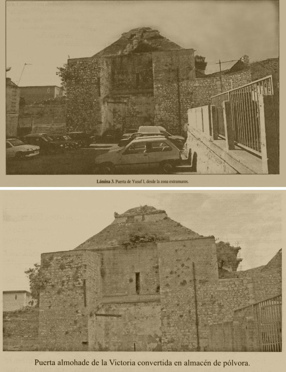
La técnica empleada en la construcción esta en consonancia con las utilizadas en periodos posteriores como son el meriní y el nazarí, con líneas de mampostería y uso de argamasas con ripios calizos o sin estos, este mismo aparejo lo encontramos en la Puerta de Yusuf, fechada en este periodo que abarca los siglos XIV y XV.
The Gatehouse was originally thought of as Abd al Mu’min’s Bab-al-Fath - lack of archaeological evidence of Almohad origins and other scholarly interpretations have led to the belief that it was originally built by the Nasrids in the 14th Century.
Their dismissal of the possibility of the gate being built during the 13th century is understandable – there is hardly any mention of the place in medieval Islamic literature of the period – even less regarding any particular caliph investing in any kind of expensive defensive improvements on a place.
In this sense Gebel Tarik had for all intents and purposes disappeared from history from 711 to the beginning of the 11th century when according to the Dutch Arabist Reinhart Dozy, the Abbadid ruler of Seville Al-Mu’tadid who at the time owned both Algeciras and Gibraltar ordered his minions . . .
. . . to write instantly to the Governor of Algeciras and order him to strengthen the fortifications of Gibraltar, bid him be on his guard and watch with outmost vigilance events on either side of the Straits.

Al Mu’tadid – King of Seville
There is unfortunately no record of what happened next, if anything at all. Nor are there any important innovations recorded from Abd al-Mu’min’s exertions in 1160 to Ferdinand IV of Castile’s lengthy instructions on what to do with his newly acquired bit of territory in 1309 – of which as far as I can make out there are few indication of which if any of his orders were actually carried out during those 24 years of the Castilian administration of the Rock.

Ferdinand IV of Castile
Nevertheless the 2006 article allows one to infer at least two things – the building techniques of the Marinids and the Nasrids are too similar to be able to distinguish archaeologically – and the second is that that la Puerta de Yusuf was probably also built within the same time scale. Their very names strongly suggest a Nasrid connection in that both might be considered as vanity projects – in particular the apparently semi-useless Puerta de Granada.
Did anybody actually ever live in Villa Vieja?
Let me quote once more from the 2006 Giles Guzmán article already mentioned above:
The interesting bit, in my opinion, is the definition of Villa Vieja as the “nucleo inicial de la ciudad.”. No evidence is offered as to when or why other than that they may have accepted an indirect generalisation by Alonso Hernandez del Portillo at face value for want of anything better.La ciudad de Gibraltar en época meriní/nazarí ocupaba la parte más septentrional del solar actual . . . Sería posible diferenciar en la ciudad tres partes principales, (a) La conocida como Villa Vieja, situada bajo el primer recinto de la alcazaba y núcleo inicial de la ciudad. Su salida al exterior se realizaba a través de la Puerta de Granada,
Hay una (iglesia) antiquísima, y está en la Villa Vieja, que como diré, este barrio y el Castillo solo tenían poblado los Moros con nombre ahora de Nuestra Señora de la Cabeza.
As I mentioned previously, the founding of Madinat-al-Fath is attributed to the 11th C Almohad era of Abd al Mu’min. The Castle and its precinct with its walls and towers were its principal features. However, whereas we are now pretty certain that the castle was not even close to the one we have today, there is less certainty as regards the size and the positioning of the walls of its precinct or indeed the rest of the Madinat.
My guess is that the general defensive improvements carried out during the 14th C would have included, of course, the sea line wall that was said to encircle Gibraltar as the halo encircled the moon – a good example of the tendency of Islamic historians to brown-nose their betters and caliphs because of course, the wall never did anything of the sort. One must add the Gatehouse and la Puerta de Granada – but I think the overall size and shape of the Castle walls remained as Abd al Mu’min intended.
My guess is that the general defensive improvements carried out during the 14th C would have included, of course, the sea line wall that was said to encircle Gibraltar as the halo encircled the moon – a good example of the tendency of Islamic historians to brown-nose their betters and caliphs because of course, the wall never did anything of the sort. One must add the Gatehouse and la Puerta de Granada – but I think the overall size and shape of the Castle walls remained as Abd al Mu’min intended.

A good view of Abu l-hasan’s Line Wall – after improvements over the years by Spanish and British Engineers (Late 19th century – Unknown Irish photographer)
The fact is that the inside of the precinct would have been an ideal place to find any vestiges of a smaller inner Almohad wall and as far as I know none has ever been found. On the contrary, sections of the present wall close to the Gatehouse have been identified archaeologically – if tentatively - as being possibly of Almohad construction.
At the risk of repeating myself, most of what we know about the building of Madinat-al-Fath comes from the Islamic historian Ibn Sahib al-Sala. Theoretically he should have known what he was writing about as he was more or less a contemporary of Abd al-Mu’min. Unfortunately, Al-Sala was also the Secretary of the treasury under the Governor of Seville Abu Yaqub Yusuf who happened to be Abd al Mu’min’s son.
It means that - surprise, surprise - he may have tended to exaggerate what Abd al Mu’min achieved in Gibraltar - which considering the lack of Almohad constructs found on the Rock, also suggests that all al Mu’min ever did was build a castle with a precinct which had a secondary area below it to the west also surrounded by defensive walls. Buildings of any importance such as principal mosques, palaces, gardens and hunting enclosures – if any - were all built or set up within the Castle proper precinct or Qasabah.
As regards the extra bit of Villa Vieja I have never come across an explanation as to why it was ever built. Why not just make the Qasabah bigger? Topographical reasons? Perhaps there was the need to build a small medieval housing estate for those involved in actually building Madinat-al-Fath – the hoi polloi who were not welcome inside their master’s territory.
Another reason might be that it was used originally as an Albacar – as a place to keep cattle and therefore separate from the main event – the castle complex. Whatever the case we know for sure that by 1627 the place was not just a cattle corral – as evidence by Bravo’s very detailed plan. On it I can count at least 20 houses and a reasonably sized church – say about 100 people in all.

Villa Vieja, its houses and its parish church – Nuestra Señora de la Cabeza (1627 – Bravo de Acuña)
Curiously, while Bravo was attempting to carry out his improvements on the fortifications of this part of town, he found to his dismay that those houses that would have to be destroyed in order to carry out his project were entitled to compensation. He managed to circumvent the problem but not before usefully leaving us according to Juan Manuel Ballesta Gómez in his Gibraltar, Siglo XVII: Hábitat, Hábitos Y Habitantes, with the following information as regards the number of houses in Villa Vieja:
Ocho adosadas al muro que separa de la Barcina y otras tantas en el centro del recinto, a un lado y otro de la Parroquia.
Another well-known Spanish historian Leopoldo Torres Balbás goes even further – albeit I think mistakenly.
En el siglo XVIII había aún en la Barcina buenas casas, algunas con «torrecillas moriscas», y jardines muy frondosos.
I suspect he misread his source - Ignacio Lopez de Ayala’ Historia de Gibraltar – where the reference was to the main town or La Turba and not la Barcina.
En la ciudad estuvieron la Calle Real y de Santa Ana, buenas casas con torrecillas moriscas, i jardines muy frondosos. (p45)
Villa Vieja was certainly not a large urban area but then I have never heard it described as such. What we have in 1627 is a small community within in a very identifiable place.

The Castle, Qasabah, Villa Vieja and the Barcina (1627 – Crop - Luis Bravo de Acuña)
Interestingly Alonso Hernández del Portillo reveals in his History that he personally was the councillor or “Jurado” for the entire area under discussion:
A el Jurado Alonso Hernández del Portillo con la gente de su Collación que era los de vecinos de la Barcina, Albacar y Villa Vieja, el Baluarte del Canuto, dicho ahora de San Sebastián (North Bsstion) y Puerta de Mar y de Tierra.
No mention of la Puerta de Granada which almost certainly must have been part of his constuency. Also the quote allows both the “Albacar” as well as the small community theory to gain credence as the words “albacar” and “Villa Vieja” appear to be linked.
Nevertheless, one further question comes to mind – 20 houses form an acceptable community but it is pretty obvious from the 1627 plan that there could have been many more. The answer probably lies with the development of the area just below it – la Barcina.
During the twelfth century this was basically an open beach. There were neither walls nor fortifications on either the northern or southern sides and the area facing the sea was simply protected by wooden stakes. Worse still the sea in those days often actually reached the base of the west wall of Villa Vieja during high tides.
It was probably one of the reasons why Ferdinand IV found it relatively easy to take Gibraltar in 1309. My guess is that it was only after the Marinid Caliph, Abu-l-hasan had just retaken Gibraltar from Castile and set about improving the Rock’s defences that la Barcina was probably made secure and inhabitable allowing many who had once lived in Villa Vieja to move to more comfortable and more easily accessible quarters in la Barcina.

A section of a well-populated la Barcina in the early 17th century
If this section of Bravo’s plan shown is anything to go by la Barcina soon became a proper mini-town with several churches, a still active atarazana or dockyard and a newly created mole – with its very own well defended Sea Gate which later became Waterport Gate. It was criss-crossed with its own streets and alleys, the one in front of the hermitage shown top right, was called el Callejon de Gonzalo García de Mendoza.
All of which is more or less confirmed by Bravo’s overview of the place.
. . . unas treinta (casas) lindando con las murallas y un islote central con el mismo número entre ambos costados de las Atarazanas. De ese total, a la tercera parte de las mismas, así como a la iglesia de San Sebastián se accedía por la vía que desde la puerta principal llevaba a la calle Real.
Finally, perhaps it is ironic that it was Bravo’s reconstruction of la Barcina’s Muralla de San Bernardo during the 17th century that ended up destroying la Puerta de Granada – or so we are told by the Spanish historian Ángel J Sáez Rodríguez in his priceless La Montaña Inexpungable. Its removal did little to dilute the Rock’s fame as an impregnable fortress – it was just a case in which it would appear that “sic transit Gloria” did not apply.
And yet . . . there are several unfortunately unverifiable conclusions that might explain some of the conundrums discussed above.
What if Villa Vieja was exactly what it said on the tin – the very first inhabitable part of the town clinging on to the apron strings of its next door protective castle – and secondly what if la Puerta de Granada had in fact been built well before la Puerta de Tierra and was therefore a very necessary entrance and exit into town from Spain and a very important addition at the time. The creation of la Puerta de Tierra may have made it obsolete but if the above is correct, then la Puerta de Granada would becomes worthy of the old Latin adage - Sic indeed transit Gloria.