
Earl of St Vincent and George Picardo - William Hargrave and James Fleming
Antonio Picardo and Roger Elliott - Bartholomé Canova and Giovanni Picardo
Abd al Mu'min
Once upon a time . . . in those far off days when Spain ruled the roost in Gibraltar - the small bays and coves of the south west of the Rock were known as calas or ensenadas and were named after nearby Catholic chapels which were found all over the place in the area at the time.

The three coves directly south of Muelle Nuebo - New Mole - and the corresponding chapels from which they took their names. Cala de San Joan - Ermita de San Juan de Verde, Cala de los Remedios - Ermita de Nuestra Señora de los Remedios) and Cala de Europa - Ermita de Nuestra Señora de Europa ( 1762 - Detail - Felipe Crame )
After 1704, however, the continuing British presence on the Rock soon led to the inevitable Spanish to English name changes to all sorts of buildings, bastions and streets. The names of the south western bays were no exception. Over the years, Cala de Europa became Europa Bay, Cala de los Remedios, Camp Bay and Cala de San Juan, Rosia Bay.
The later was sometimes also sometimes referred to as Rosier Bay and during the Peninsular Wars as Rosia Harbour, but, and unlike the other two bays, the name Rosia seems to have been used almost indiscriminately throughout the immediate area. For example, by the time Admiral the Earl of St Vincent, instigated the construction of the well-known nearby water tanks in the late 18th century ( see LINK ) 1 he was living in a premise in Rosia Parade known as Rosia House. 2

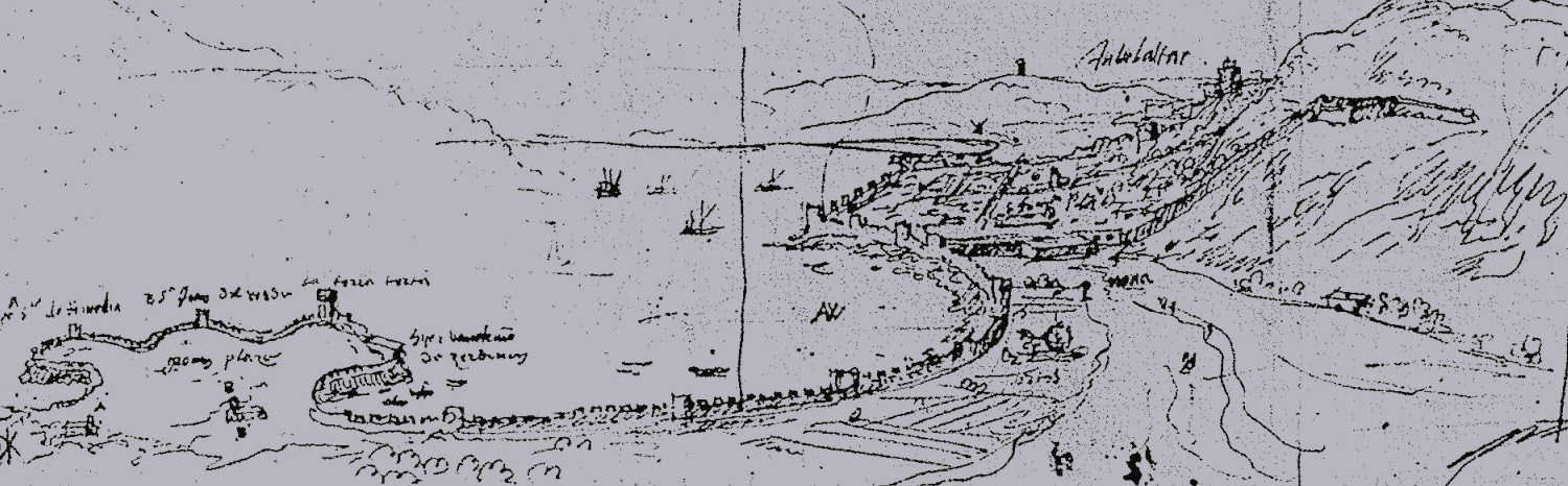
The south western coves with British names ( 1874 - Detail - G. Muller )
Map makers were slow to adopt the English nomenclature although Rosia Bay was one of the first to make its appearance. There was also an odd reluctance to lose any of the original names. It meant that whereas Rosia Bay took the place of La Cala de San Juan Verde, the latter continued to appear on maps as just north of Rosia Bay and south of the New Mole.

Rosia Bay takes over from the Calita de Juan Verde which is moved towards the next available space south of the New Mole ( 1738 - Tindal and Rapin )
The fluctuating changes of the names of the three bays can be traced in the literature - Europa Bay, despite its appearance on the above late 19th century map is today known as Little Bay and was already known as such by the Garrison during the Great Siege. As Captain Spilsbury (see LINK) wrote in his diary;
A Corsican escaped or deserted from their fleet . . arrived at Little Bay. 3
The reasons behind the choice of these names was probably quite trivial - there were military camps just above Camp Bay in the 17th and 18th century, and Little Bay is indeed rather small. But the rational for calling Rosia Bay - and a considerable chunk of the surrounding countryside - after a relatively obscure chapel is less easy to understand, especially when one considers that the name of the chapel itself is spelt differently everywhere one looks - from Rocio, which means 'dew' to Rosa and Rose - not to mention Rosio and Rosia, both of which are meaningless.
That some sort of building with a name corresponding to at least one of these varieties actually existed is unarguable. There is an embarrassment of 18th and 19th century maps pinpointing the chapel in question as either Rosia or Rose - although never by its presumed proper name of Rocio.

The label O is captioned elsewhere on the map as 'Rosia'. The enclosed area surrounding the chapel could be a garden known as the Vineyard and renown at the time for its beauty ( 1720 - Detail - Hermann Moll )

The chapel as S.Rosia ( Post 1704 - Detail - unknown French cartographer )

The chapel as Sta Rosa ( 1762 - Detail - Felipe Crame )

The chapel as Sta Rosia ( 1799 - Detail - Barbie de Bocage )
As regards very early British literature on Gibraltar, Rosia is only noticeable for its absence.
John Durant Breval, ( see LINK ) writing about Gibraltar in 1726 makes no mention of any of Gibraltar's religious buildings. An etching of the south prospect of the Rock which he included in the book the bay is simply captioned as 'the back of ye New Mole'. 4

From John Durant Breval's Remarks on Several Parts of Europe ( 1726 )
However, according to Alonso Hernández del Portillo, ( see LINK ) most of area behind these coves - from the sea perhaps right up to the cliff face - was mostly occupied by well cultivated orchards and gardens.
Acabando los arenales (the Red Sands) comienzan las huertas que son de arboles de frutas sabrosísimas y de muchas diferencias y muy alabadas de los forasteros y naturales.. . . La Iglesia de San Juan de Verde . . se dijo verde por que el día de su fiesta esta todo su campo verde. Dicen otros que por estar esta ermita entre las huertas . . . 5
Portillo's is a history of Spanish Gibraltar in the early 17th century but it would be safe to say that his description of this particular area would still have been valid several decades after Gibraltar had been taken over by the British.
In 1748, for example, Robert Poole (see LINK), a medical man and an obsessively religious writer of theology, set out on a voyage to the West Indies. The first leg was from London to Gibraltar where he stayed for nearly a month. Among his diary entries are two references to a place which he called 'the Vineyard.'
After this ( a visit to the Naval Hospital situated about a mile out of town beyond the new Mole ) we visited what is here called the Vineyard. It is a pretty large piece of garden, lying upon a descent, in the occupation of one who rents it, maintain himself and his family by the profit thereof . . . .
Returning from on board the ship this forenoon, I again visited the garden called the Vineyard . . . 6The lessee in question was a Gibraltarian of Genoese origin called George Picardo and the man he rented it from was Lieutenant-General William Hargrave, one of a long-line of rather unscrupulous Governors of the Rock who - together with his secretary Captain James Fleming - was later accused of extortion. 7
According to the records of a Court of Enquiry set up in 1748, 3 in 1708 a house and what was then a small garden was leased to a local resident - an immigrant from Genoa called Antonio Picardo - by Colonel Roger Elliott, yet another shady character who happened to be Governor at the time. 8
There is evidence elsewhere that Antonio actually managed to obtain this concession through marriage. It was another Genoese, Bartholomé Canova who was originally given permission to live in a ‘cottage and garden near the New Mole’ and from which he produced vegetables which he sold in town. When he died his widow married Antonio Picardo. 9
It was Antonio's son George who was in charge by the time Poole came avisiting and his description of the place suggests that its name- the Vineyard - was something of a misnomer.
Here are plenty of lemons, quinces, pomegranetes etc also garden greens, peas now in bloom and other still younger coming forward. By the side of the garden is a locust tree . . It bears pretty large pods . . said to be used only as food for asses, here called 'Borekers'. (Borricos). In various places . . . plenty . . . of the aloe plant . . . Here are also prickly pears and several palm trees . . . 6It is probably worth mentioning that the Picardos generally seem to have been superb horticulturalists - to such an extent that one is inclined to suppose that it was this family that gave rise to the local tradition that the Genoese were the best gardeners in town.
Agustin for example also owned another 'huerta' inside the moat of Charles V wall. He had bought it from a Spaniard, Ignacio Reyes for 400 duros. His son Giovanni Picardo inherited the place when he died.
Nevertheless, a careful scrutiny of the above reveals that although 'houses' and 'cottages' are mentioned, chapels or ermitas are not - an odd omission as the gardens in question were almost certainly those of Nuestra Señora del Rocio.
Curiously, Poole does give elsewhere a list of all the batteries he visited on the Rock, among which was one called Rosia Battery. It is possibly the first mention of the word 'Rosia' in the British literature. 5
In 1771, Lieutenant Colonel Thomas James (see LINK ) also wrote about his experiences in Gibraltar while he was stationed there for several years during the mid 18th century. His description of the area makes a first clear connection between the Vineyard and its chapel.
Between the hospital ( Naval Hospital) and barracks (South Barracks) is a large inclosed piece of ground called the Vineyard ; in it are many trees, and plenty of roots, herbs, sallads, &c. in their proper season, and is by far the pleasantest spot on the rock : it was originally a religious house, called St. Rosia.( Ermita de Nuestra Señora del Rocio)
On the side of the hill leading to the north pavilion, and near the line wall, are two small houses; which spot formerly had a chapel erected on it dedicated to St. John. ( San Juan el Verde) The remains of a Moorish well stand close to the eastward house, from which earthen pipes went down the hill. aslope, through the line wall, at which place some of the Moors and Spanish gallies watered : part of the pipes are still to be seen. 10

The 'garden' between South Barracks (see LINK) and the Naval Hospital is almost certainly the Vineyard. It is shown just above Rosia Bay.

Rosia Bay, Camp Bay and the chapel of Santa Rosia between South Barracks and the Naval Hospital. The enclosed area surrounding S. Rosia is almost certainly the Vineyard ( 1799 - Detail - Barbie de Bocage )
The mention of earthen pipes used to supply water to the Galleys is possibly a clue as to why the Vineyard was considered such an attractive spot - water was and always has been a rare resource on the Rock. It is in fact possible that the garden was quite close to the original springs used by Muslim engineers in the 12th century to supply Abd al Mu'min's newly created town of Medinat al Fath - Moorish precursor to the town of Gibraltar. ( see LINK ) 11
By 1782, the chapel seems to have disappeared, but the garden or Vineyard persists albeit with a different name. B Cornwell ( see LINK ) in his book on the Great Siege, calls the place George's Vineyard. 12
His contemporary Samuel Ancell in his account of the Great Siege also refers to the garden as George Picardo's vineyard, while acknowledging both its money making potential and its limitations in time of war.
Near the New Mole . . . is a pleasant vineyard, of a small length, which yields a great quantity of vegetables, but not sufficient to supply a sixteenth part of the garrison. It is supposed that the owner clears five thousand dollars per annum by it.
. . . a shell fired from St Carlos, fell near George Picardo's vineyard, ( see LINK ) where it burst, but did no damage . . . . 13
From the 19 th century onward, however, neither the chapel nor 'the Vineyard' continue to appear in either maps or the literature. Presumably they either no longer existed or were of too little consequence to mention.

No chapels and no Vineyard ( 1874 - Detail - G Muller )

The Bay and the entire area shown as Rosia ( 1878 - Detail - Montoyo y Salcedo )
In 1977 local historian George Palao wrote an exhaustive survey of all the pre-1704 churches of Gibraltar. It included Nuestra Señora del Rosio - which he translates as Our Lady of the Dew and describes as follows.
This shrine stood above the wooden steps leading down to Camp Bay and just south of Parson's Lodge . . . 14
Which is not where everybody else places it. He gives no reference and if one takes it for granted that he was not mistaken, then one must suppose that there might have been more than one chapel called Rocio/Rosio/Rosia/Rosa.
That other Gibraltarian stalwart, Dorothy Ellicott also describes it in almost the same words which leads me to suspect that one of them was quoting the other, although she does add that there was still a building standing in its place in the 1970s called 'the Hermitage'. 15

Photo of the Rosia area with Rosia Bay in the distance. The chapel had already disappeared but the wooden steps leading down to Camp Bay as mentioned by Palao are clearly visible ( 1870 Detail - George Washington Wilson )
Both historians, however, are skeptical as to the origins of the term 'Rosia Bay'. According to Ellicott;
Rosia is said to be a British corruption of the name of the shrine of Nuestra Señora del Rocio. ( our Lady of the Dew) which stood above the ladder heading down to Camp Bay. where there is still a house called the Hermitage. Unfortunately for this theory the Bahia de Rosia is clearly marked on a Spanish Plan dated 1627. A later Spanish map calls the Bahia de Santa Rosa. 15
Unfortunately I cannot find a single pre-British map with the elusive chapel on it. A map produced in 1608 by the Spanish engineer Cristóbal Rojas carefully positions two nearby churches on either side of it - San Juan ( San Juan de Verde - not far to the south of British map placings of Rosia) and Los Remedios ( Nuestra Señora de los Remedios - not far to the north of British map placings of Rosia). But of Rocio/Rosio/Rosa/Rosia there is no sign.

The south ( 1608 - Detail - Cristóbal Rojas
Exactly the same situation is found in Luis Bravo de Acuña's map of 1627 - a very attractive candidate for the one offered as testimony by Palao and Ellicott - again a mention of San Juan el Verde and Remedios but no Rocio. ( see LINK )

The south ( 1627 - Luis Bravo de Acuña )
Going even further back the Dutch cartographer Anton van Wyngaerde ( see LINK ) made a series of small sketches of the Rock prior to completing his well-known picture map of the Rock. One of these sketches shows the 'Rosia' area.
The town is viewed from the south with Sierra Carbonera in the distance sporting its tower. Harder to make out is the Puerta Nueva through Charles V Wall which is indicated by an arrow and the words p nova. On the left hand side the Torre del Tuerto appears as la torra torta . The two churches labelled A and B, are Na Sr de los Remedios and San Juan Verde respectively and the area in front of the churches seems to be labelled Joan Plaza. Once again, no mention of anything remotely like Rocio.
West side of Gibraltar looking north ( 1567 - Anton van Wyngaerde )
Even more unfortunate is the fact that I can find no mention of any chapel called Nuestra Señora del Rocio - or any other possible other alternative spellings of the name - in pre-British histories.
Alonso Hernandez del Portillo is a case in point. Here is a meticulous historian who carefully describes and places what appears to be a comprehensive list of local churches and chapels yet fails to mention Nuestra Señora del Rocio - while tantalisingly describing two other nearby churches on either side of it:
Acabando los arenales ( the Red Sands) comienzan las Huertas . . Esta entre estos huertos la Iglesia de San Juan de Verde que es de la encomienda de los Caballeros de San Juan del hospital, que ahora dicen de Malta. . .
Un poco más adelante esta otra ermita de Nuestra Señora de los Remedios, imagen my devota y con quien se tiene en esta ciudad mucha devoción. 5
In other words this elusive chapel seems to have been quite well known during the first century of British occupation but for all intents and purposes practically unknown in Spanish Gibraltar.
All this of course does not discard the idea that Rosia Bay was indeed named after a chapel known to the British as Sta Rosia. In fact I would go so far as to say that this interpretation is to be preferred to one suggested by Wikipedia - the internet encyclopedia - which blandly suggests that the bay was named after a monastery town near Sienna in Italy which was also called Rosia . 16 No references are offered and I can find no evidence for this.
One rather unlikely theory that would explain the lack of evidence for a Spanish Chapel of that name is that in during the Spanish era it was one and the same as Nuestra Señora de los Remedios. For example the Virgin in the Hermitage in Huelva was once called La Virgen de los Remedios but is popularly known as el Rocio - which in religious symbolism refers not to dew as such but to the 'blessings offered by God'.
Just about the only attractive thing that can be said about this theory is that the church of Los Remedios was actually converted into a barracks and that the area was later used to build the Naval Hospital. All of which may have increased the status of its name in the eyes of the British at the time. 15
Even more irritating is the fact that of all three chapels, San Juan el Verde probably has a greater claim over Rosia Bay than any of the others. The house belonging to the priest responsible for looking after this hermitage was built on the southern outcrop of the bay, hence the name of the battery which was eventually built over it - Parson's Lodge. 15

Looking south from Buena Vista ( 1828 - T.M. Baynes )
Perhaps a more likely - and from my point of view as a Gibraltarian a more attractive theory - could be summarized as follows.
1. The church or hermitage was of such insignificance during the Spanish era that it was hardly worth mentioning.
2. After the place and its grounds were handed over to the Picardo family in the early days of the British occupation, it became better known, not as a chapel but because of the its gardens - the so-called Vineyard. That it had probably never been a building of any great size or usefulness is confirmed by the fact that the British never bothered to convert it into either a barracks, a magazine or a store - as they invariably did with other Spanish Chapels - and simple leased it out to a local.
3. With the passage of time the whole area occupied by the garden from the cliffs to the sea and from San Juan to Los Remedios - itself used as a barracks in the early 18th century - began to be referred to by the British as Rosia.
4. Meanwhile. the Bay, Gibraltar's only natural harbour also came into its own as it was used more and more both for commercial and military purposes. During the late 18th and middle 19th century its importance as a naval base exceeded both its size and victualling capacity.
5. And from there one small step to calling it . . . Rosia Bay.
And yet, and yet . . . I am still not at all sure that I haven't missed something important.