
1758 - A Plan to Invade Gibraltar - Northern Section

Northern Section - Covering parts of the Isthmus
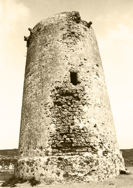
3. Torre del Diablo
Not on the caption list but easily identified as a coastal, medieval watchtower known as La Torre del Diablo - Devil's Tower. (See LINK)

La Torre del Diablo (1727 - Antonio de Montaigu de la Perille)

Devil's Tower (Early 20th century)
29. raya q’ dibide el termino de españa
A theoretical dividing line showing the limits of Spanish sovereignty. This is one of those moot points which would have caused apoplexy if it had come to the attention of the Spanish Court. Difficult to summarise the problem succinctly but here goes.
Just after the ceasefire that ended the 13th Siege of Gibraltar - and two years before the Treaty of Seville was signed in 1729, (see LINK) the Spaniards began work on the isthmus intending to increase the strength of their defensive position.
Lord Portmore, the Governor of Gibraltar at the time, protested but the Spaniards insisted that under the Treaty of Utrecht (see LINK) they were entitled to do whatever they wanted on the isthmus. Yet out of the blue and as a more than surprising gesture of goodwill the King of Spain issued a Royal Ordinance which instructed his troops to retire to a line 600 “toises” - about a thousand meters - from the base of the Rock.
Lord Portmore, the Governor of Gibraltar at the time, protested but the Spaniards insisted that under the Treaty of Utrecht (see LINK) they were entitled to do whatever they wanted on the isthmus. Yet out of the blue and as a more than surprising gesture of goodwill the King of Spain issued a Royal Ordinance which instructed his troops to retire to a line 600 “toises” - about a thousand meters - from the base of the Rock.

The Earl of Portmore
The King’s diktat has been misinterpreted over the centuries both by the British and by the Gibraltarians. They both claim that it acknowledges their right of ownership of almost the entire isthmus. Unfortunately the King - Philip V - made it very clear in his protocol that while he had allowed his troops to retire this did not mean he was surrendering Spanish sovereignty over the isthmus.

A modern Spanish perspective
31. baluarte de Santa Barbara -
32. baluarte de San Felipe.
These three defensive structures were eventually known collectively as La Linéa de la Contravalación but originally as Linéa de España or Linéa del Campo. The works were completed in 1735 hence giving an earliest possible date to the map. (See LINK)

La Linéa de la Contravalación (1735 - Juan de Sobreville)
33. batería de la Tunara
Torre de la Tunara - A coastal medieval watchtower now known as Torre Nueva.
Torre de la Atunara
34. Rio de Guadiaro
One of several Campo rivers flowing into the Mediterranean.
35. la Chulera - desde dicho sitio no se ve el monte
A reference to another medieval watchtower known as la Torre de la Chulera - I am not sure whether the geography could have changed so drastically during the last two and a half centuries but the Rock is today perfectly visible from the tower.

La Torre de la Chulera
36. punta mala
Nowadays Punta Mala is a small cape on the north eastern side of the Bay. It forms part of the municipality of nearby San Roque. The Bastion of Punta Mala was constructed in 1735.

Fuerte de Punta Mala (1735 - Juan de Sobreville - Campo de Gibraltar)
See also:
1758 - A Plan to Invade Gibraltar - Introduction
1758 - A Plan to Invade Gibraltar - Middle Section
1758 - A Plan to Invade Gibraltar - Southern Section
With thanks to genealogist Georgina Marks who supplied me with all the information I needed to write the above. All the mistakes are mine. Thank you Georgina.